Chesapeake Bay Algal Blooms
About this Inquiry
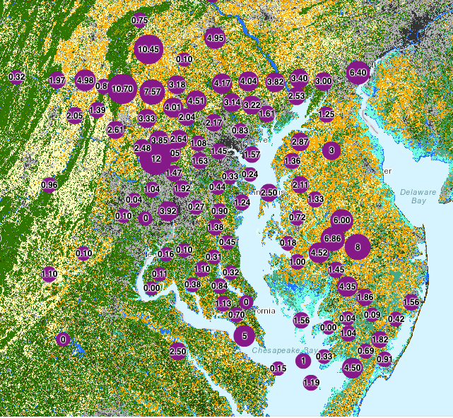
In this inquiry, students engage with mapping data to determine what kind of land coverage is contributing the most to harmful algal blooms in the Chesapeake Bay Watershed. These harmful algal blooms are often the result of nutrient runoff from surrounding land, leading to higher concentrations of nutrients like nitrogen and nitrates in the water. This inquiry has students look at water quality data, specifically observed nitrate levels, collected by citizen scientists in partnership with the NOAA Chesapeake Bay Office. Students analyze and interpret a land coverage map in FieldScope to determine what kind(s) of land coverage is/are most associated with higher levels of nitrates in the watershed. The students will filter the data to observe patterns more easily. They then write a letter to local activists about what kind of land coverage should be addressed to mitigate nitrate runoff. In this letter, after reading about the Environmental Protection Agency’s recommendations, students will also identify five key locations at which the activists should advocate for field buffers and fence construction to reduce nitrate leakage into the watershed.
Instructional Days
2 days
Learning Goals
- Use graphical displays (e.g., maps, charts, graphs, and/or tables) of large data sets to identify what kind of land coverage has higher levels of nitrates in the water nearby.
- Analyze and interpret data to provide evidence for where runoff management projects should occur.
The content in this investigation is about factors affecting algae growth and harmful algal blooms. This is related to NGSS Disciplinary Core Idea (DCI) MS-LS2.A, “Organisms, and populations of organisms, are dependent on their environmental interactions both with other living things and with non-living factors”. However, this inquiry does not directly support students in figuring out this specific DCI.
Type of Analysis
- Mapping – Spatial Analysis
- Mapping – Filtering Data by Value
About this Citizen Science Project:
The Chesapeake Bay Watershed Project is a citizen science initiative in which community members and students investigate water quality issues on local and regional scales and collaborate across the Bay Watershed to analyze data and take action. It is run in collaboration with the NOAA Chesapeake Bay Office. The project is open and free for students and educators across the Chesapeake Bay Watershed to join. Classrooms can choose to collect and contribute data to this project or to analyze the existing data, including data from other classrooms and citizen science groups around the watershed, as well as data from government agencies.